Cyprus
Earth Observation Data Cube
Earth Observation Analysis of Cyprus
“Your gateway to Cyprus from space”
About
Data Cube
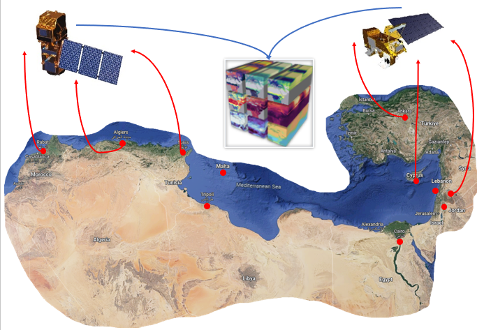
Earth Observation Data Cubes are spatio-temporal management databases for data derived from different sources, mainly satellite-based remote sensing. Through Data Cubes, researchers can analyse and process sheer volume of earth data and get a better understanding of our world. Cyprus Data Cube was developed under the framework of EXCELSIOR H2020 project. The Cyprus Data Cube is managing data from different satellite sources from NASA’s and ESA’s missions.

What You’ll SEE
Remote Sensing
Data Acquisition from satellites
Information Extraction
Understanding the environment
Data Analytics
Data Processing
Data Collection

Aqua and Terra satellites
We collect various products for evapotranspiration, agriculture monitoring, wildfires and land surface temperatures mainly from MODIS Instrument.

Sentinel-1 & Sentinel-2 satellites
We collect optical images with Multispectral Instrument from Sentinel-2 and radar images with C-band Synthetic Aperture Radar instrument from Sentinel-1.
Data Analytics
JupyterHub is an analytical framework, scientists and academics from all over the world can examine earth data over Cyprus and draw insightful conclusions.

Registration Process
Sign Up
Review of your
Registration
Your account is
authorized
Access to
Analytics Platform
**Disclaimer Access to Cyprus EO Data Cube is for research purposes only and strictly prohibited from being used for any commercial purposes.
Functionalities
Different Programming
Languages
Jupyter supports over
40 programming languages,
including Python, R, Julia, and Scala
Share Notebooks
Notebooks can be shared
with others using email, Dropbox,
GitHub and the Jupyter Notebook Viewer
Interactive Output
Your code can produce rich,
interactive output: HTML, images, videos,
LaTeX, and custom MIME types.
Big Data Integration
Leverage big data tools, such as
Apache Spark, from Python, R, and
Scala. Explore that same data with pandas,
scikit-learn, ggplot2, and TensorFlow
Important Aspects
Analysis Ready Data
Analytical framework
Information Products
Consortium


Affiliated Entities


The EXCELSIOR project has received funding from the European Union’s “Horizon 2020 research and innovation Programme” under Grant Agreement No 857510

The EXCELSIOR project has received funding from the Government of the Republic of Cyprus through the “Directorate General for the European Programmes, Coordination and Development”.

The EXCELSIOR project is co-funded by the Cyprus University of Technology.
If you want to contact us.
Let’s talk!
Get In Touch
- Franklin Roosevelt 82, Limassol 3012, Cyprus, Limassol, Cyprus
- +357 25002908
- info@cyprusdatacube.com
Send Me a message
If you want to contact us.
Let’s talk!
Get In Touch
- Franklin Roosevelt 82, Limassol 3012, Cyprus, Limassol, Cyprus
- +357 25002908
- info@cyprusdatacube.com


